The Crashed Plane Hike
Peak District · Circular · thelostpeak.co.uk
Start & parking
Free lay-bys along both sides of the A57 at the top of Snake Pass, right at the start of the walk, open 24 hours a day.
Route map
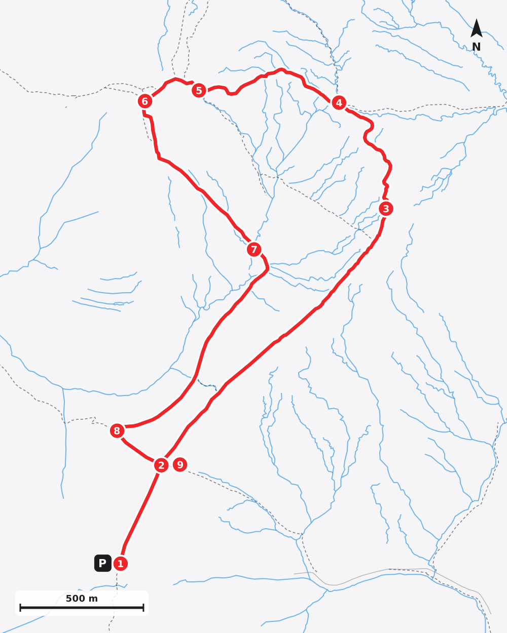
Detailed directions
- 1Onto the Pennine Way0.00–0.27 mi
From the lay-bys at the top of Snake Pass, go through the gate just off the road and follow the flagged Pennine Way north. After about a quarter of a mile you reach a crossing with the Doctor's Gate bridleway, the path you come back on at the end. Keep straight on, north.
- 2North-east along Devil's Dike0.27–1.15 mi
Carry on along the flagged path as it heads north-east along Devil's Dike, almost level, for about 0.9 mi. Ignore two paths that branch off to the left.
- 3North up Hern Clough1.15–1.52 mi
The path swings north and passes a cairn, then follows the stream in Hern Clough, with the water on your right. After about 0.35 mi it crosses the stream at two fords close together.
- 4Left off the Pennine Way1.52–1.94 mi
Just past the fords, bear left onto the path heading west across the moor; the Pennine Way carries on north. Follow it for about 0.4 mi, climbing gently and crossing several small streams.Navigation care needed: this is the turn to check on your map. The Pennine Way carries straight on north; our path leaves it, heading west across open moor.
- 5The B-29 crash site1.94–2.11 mi
Turn right onto the path heading north-west, where another path goes off to the left. Pieces of wreckage from the B-29 Superfortress Over Exposed lie beside the path, then you reach the memorial. Bear left here, south-west, for about 150m to a junction just below the top of Higher Shelf Stones.
- 6Over Higher Shelf Stones2.11–2.61 mi
Turn left, south, over the top of Higher Shelf Stones (622m). Just beyond it the path forks: take the left fork, heading east and then south-east down across the moor. The path straight on, south, is not our way. It drops about 80m in half a mile, crossing two small streams, to ford the stream in Crooked Clough.Navigation care needed: the path across the moor is not always clear on the ground. In mist, check you have taken the left fork, east, off the top.
- 7Along the edge above Crooked Clough2.61–3.26 mi
After the ford the path swings south-west and runs along the edge above Crooked Clough, with the clough below on your right, for about 0.65 mi. A fence runs alongside on your right for a stretch, and you cross a few small streams. Near the end, keep left where a path carries on west, and you meet the Doctor's Gate bridleway.
- 8Left along Doctor's Gate3.26–3.41 mi
Turn left onto the Doctor's Gate bridleway, heading south-east and gently uphill, for about 250m to the crossing with the Pennine Way that you passed at the start.
- 9Back to Snake Pass3.41–3.68 mi
Turn right onto the Pennine Way, heading south-west; the bridleway straight on is not our way. Retrace your outward steps for about a quarter of a mile, back through the gate to the road.
Safety: Route information and GPX files are provided for general guidance only. Conditions can change, so always use your own judgement and navigate responsibly. See our Terms of Use & Disclaimer for more information. Hills can be dangerous: carry a map and compass and know how to use them, check the mountain forecast before you set off, and turn back if conditions change.